
Property & Planning
A Property Positioned in Bandon’s West-Side Growth Area
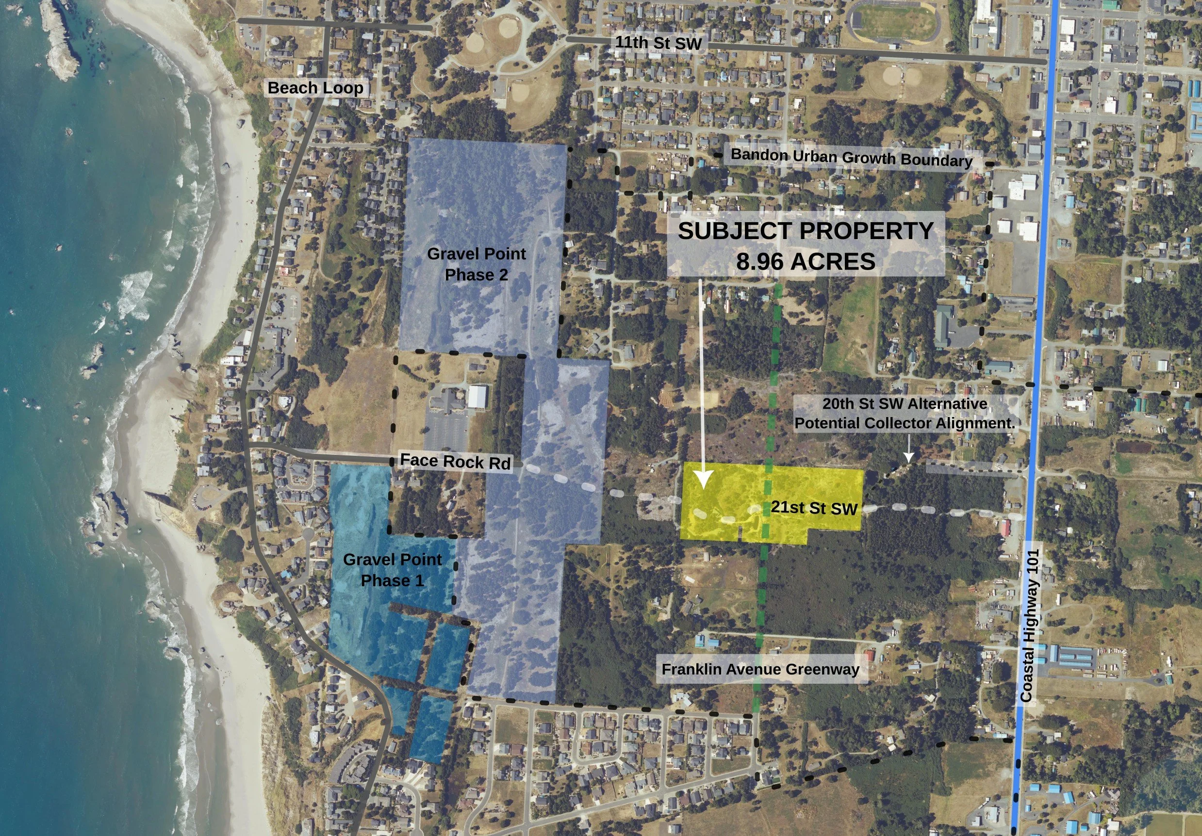
The approximately 8.96-acre property lies within Bandon’s Urban Growth Boundary, west of Highway 101 and between Douglas and Harrison Avenues.
Its significance is not simply its acreage. The property occupies a key position between existing city neighborhoods, Highway 101, the emerging Gravel Point development area, and Bandon’s oceanfront.
Long-range transportation planning places an important east-west connection through this area, while future urban utilities and street improvements have the potential to substantially change how this land functions.
Aerial imagery: Oregon Statewide Imagery Program (OSIP), 2024. Coos County Assessor parcel/GIS data where shown. Public-agency planning sources; graphic and annotations by Seller using QGIS. Boundaries, routes, distances and shaded areas are approximate and for illustration only. Parcel lines may not coincide with legal surveyed/legal property lines. Proposed improvements are subject to final design, approvals and change. Not a survey, legal description or engineering plan.
Explore Face Rock Heights
Explore the 8.96-acre property, surrounding coastal context, site features, photos and video.
Take the Guided 3D Property Tour
Explore transportation, wetlands, floodplain, terrain and other property context in a guided interactive tour.
1. Five Tax Parcels — With an Older Platted-Lot Pattern Beneath Them
The property consists of five current tax parcels totaling approximately 8.96 acres according to Coos County Assessor records.
Beneath the five current tax parcels lies a historic subdivision comprising 154 previously platted residential lots, generally measuring 25 × 100 feet. This underlying subdivision pattern distinguishes Face Rock Heights from conventional large-acreage properties.
That underlying platting is an unusual characteristic of the property and helps illustrate that this area was contemplated for urban-scale development long before modern infrastructure reached it.
The historic lots should not be interpreted as confirmation that each individual lot is presently buildable. Current development would remain subject to applicable zoning, access, utilities, development standards, and governmental approvals.
2. Inside the Urban Growth Boundary
The property is presently under Coos County jurisdiction and is zoned UR-2 while remaining inside the City of Bandon Urban Growth Boundary.
Its location within the UGB is important. This is not remote rural acreage separated from the city by miles of undeveloped land. It lies immediately within Bandon’s west-side urban expansion area and between already-developed neighborhoods and major planned improvements.
Future annexation, rezoning, subdivision, or development would require the applicable governmental processes and approvals.
3. Future Utilities and Urban Infrastructure
Road construction and development in this area are expected to be accompanied by expansion of urban infrastructure.
The Gravel Point development process and related planning contemplate extension of city services through portions of the area. The exact timing, alignment, capacity, cost allocation and availability of utilities to the subject property will depend upon final engineering, governmental approvals and agreements.
For a future owner, however, the important planning distinction is straightforward:
Face Rock Heights occupies a strategic position at the crossroads of Bandon's planned west-side transportation network, with anticipated City infrastructure extending through or alongside the property as surrounding development progresses.
That distinction is central to its long-term development potential.
4. A Strategic Piece of the Larger Street Network
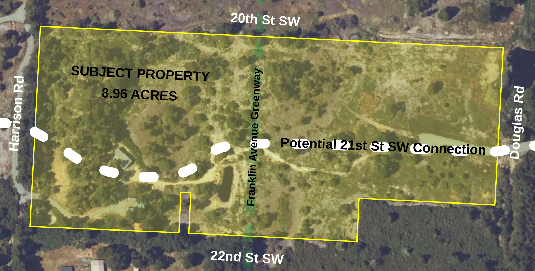
The property also lies along the historic Franklin Avenue alignment, creating a north-south planning relationship in addition to the proposed east-west 21st Street connection.
Together, these alignments help explain the property's unusual location within the broader west-side street network.
Rather than functioning as an isolated tract, the property sits at what may ultimately become an important crossroads within the emerging Face Rock Heights area.
That location is one reason the property may have strategic value beyond what would typically be inferred from acreage alone.
5. The Planned East-West Connection
Existing Access from Two Directions
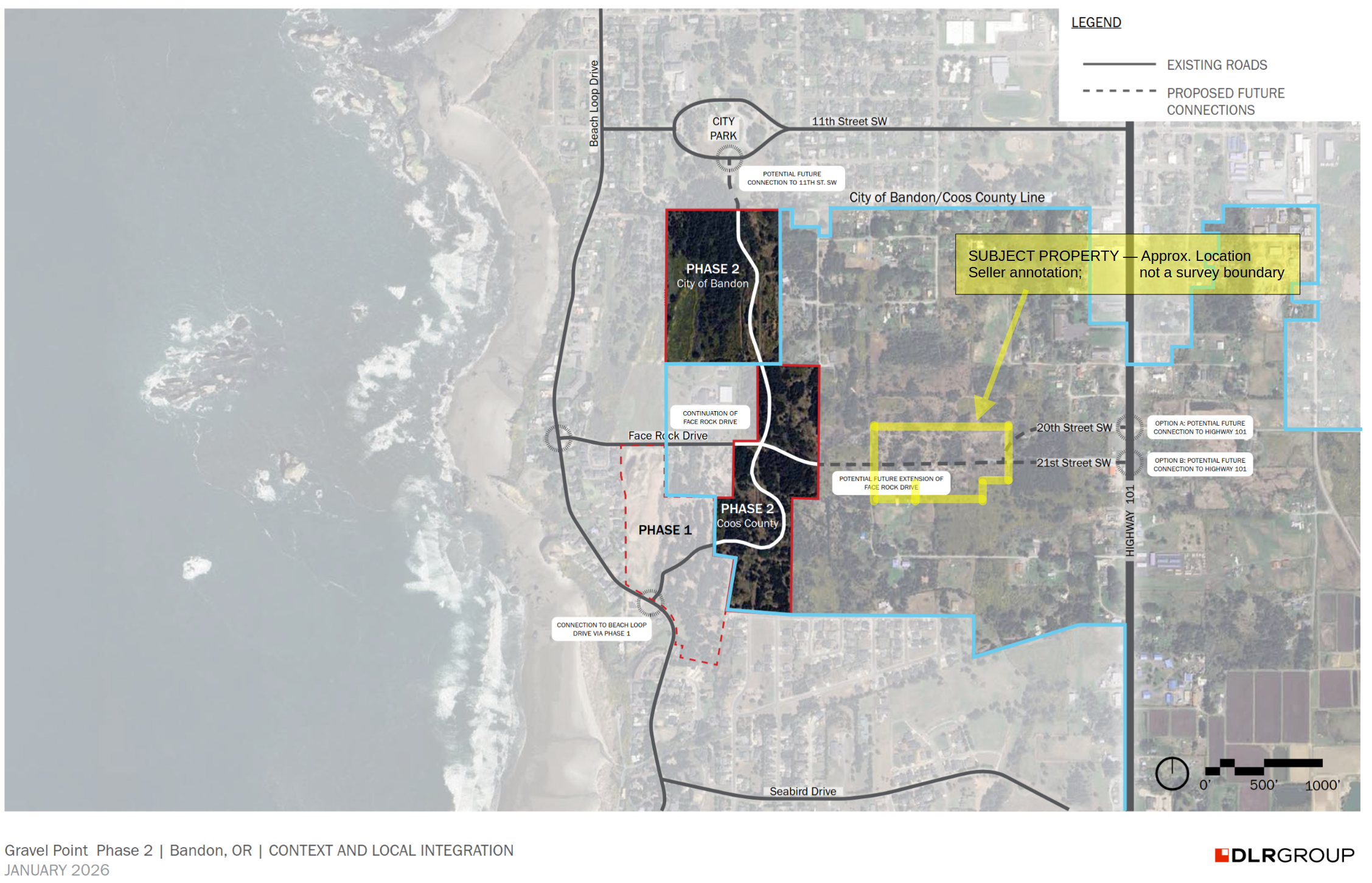
Face Rock Heights currently benefits from two established approaches: county-permitted 21st St SW gravel access from Highway 101 at Mile Marker 275 to the east, and separate Harrison Road access serving the existing homestead to the west. These existing approaches are distinct from the contemplated future east-west collector connection.
The adopted 2025 City of Bandon Transportation System Plan identifies an east-west collector using the 20th Street SW corridor. Subsequent Gravel Point Phase 2 applicant materials depict two potential future Highway 101 connections: an option at 20th Street SW and an alternative at 21st Street SW.
The 21st Street SW corridor is also identified in applicant materials as the proposed construction-access route. The final permanent collector alignment remains subject to engineering, development review, right-of-way considerations and governmental approvals.
The subject property occupies an important position under either potential alignment. A 21st Street connection would traverse the property generally east-west through its interior; a 20th Street connection would run along or immediately adjacent to its northern boundary.
Under either alignment, Face Rock Heights retains its strategic position at the crossroads of Bandon’s planned west-side transportation network, connecting Highway 101, Gravel Point, the Face Rock and Beach Loop areas, and surrounding neighborhoods. This location offers significant long-term connectivity potential, with planned transportation improvements, multi-modal pathways, and anticipated City water and sewer infrastructure extending through or alongside the property as surrounding development progresses.
6. Development Potential — Without Presuming the Outcome
The property offers several characteristics that could be relevant to a future developer or long-term land investor:
approximately 8.96 contiguous acres;
location inside the Bandon Urban Growth Boundary;
an underlying historic subdivision comprising 154 previously platted residential lots;
frontage or potential frontage on planned transportation improvements;
proximity to anticipated urban utilities;
adjacency to significant surrounding development;
existing access from both Highway 101 and Harrison Road;
a central west-Bandon location; and
convenient future pedestrian access toward the beach and oceanfront.
These characteristics do not constitute an entitlement or guarantee a particular development density, use, street alignment or financial outcome.
They do, however, place the property in an unusual planning position: a substantial privately held tract directly within the path of Bandon’s evolving west-side urban network.
For detailed zoning, transportation, easement, utility and valuation analysis, see the Seller’s Assessment available on the Documents page.
Planning information is presented for general marketing purposes. Prospective purchasers should independently verify zoning, boundaries, utilities, access, development standards, governmental approvals and other matters material to their intended use.